The Semi Tropic Spiritualist Tract
Please go to theasphaltisland.weebly.com
For an updated, corrected, and expanded version of this article,
now called "The Lasso of La Loma"
Updated with a registry of all the house numbers on these streets.
CLICK HERE TO GO TO THE UPDATED VERSION.
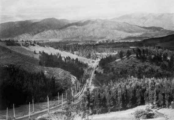
...like most LA communities on the outskirts of Downtown around the turn of the 20th century, "Edendale", as the area was then-called, was something of a pastoral scene--a sprawl of ranches and native chaparral forests along rolling hills. As you stand on the very, very northernmost tip of Alvarado Street, you can almost, barely, still see it with your own eyes:
The Pacific Electric Red Car ran roughly down the path today containing the Allesandro Freeway (south end of California State Route 2); the hills of Silver Lake, Echo Park, and Elysian Heights had only begun to exhibit little wooden bungalows; the Mediterranean air and landscape was largely unadulterated by industry and development; the graffiti-covered sound walls were clusters of Coast Live Oaks, Black Walnuts, Big Leaf Maples etc.; and what is now South Glendale and beyond was a sizable ranch called "Tropico". Oh, and nearby, over by the Silver Lake Reservoir on what is now Ivanhoe Drive, newly-coined "anarchists" the Flores-Magon Brothers and Emma Goldman were layin' low. This, along with other attributes and residents, gave way to the old-timer moniker of "Red Hill".
While the central city had begun to grow at its fastest rate during this period, the period from 1890 to 1930, and as little streetcar suburbs (Angelino Heights, Highland Park, Echo Park) began popping up, there were still, among the new Angelenos, those who sought a lifestyle away from the codependency of modern society. Secluded communities still flourished in the hills north of Downtown, among these Mount Washington, Mount Angelus, as well as "stair streets" and "walk streets" like Fellowship Park in Elysian Heights. The locale and personality of these places was, and is, pretty different from the Central City. One of these communities, in present day Elysian Heights, was the Semi-Tropic Spiritualist Grounds.
History
THE SPIRITUALISTS
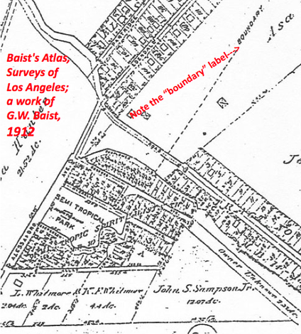
The Semi-Tropic Spiritualist Association settled their Tract circa 1905-1912 on the north end of the hills of Echo Park, upon a 3-acre parcel that was at the time just outside of L.A. city's northern boundaries.
THE SPIRITUALISTS
The Semi-Tropic Spiritualist Association settled their Tract circa 1905-1912 on the north end of the hills of Echo Park, upon a 3-acre parcel that was at the time just outside of L.A. city's northern boundaries.
From what we do know, the Semi-Tropic Spiritualist Tract housed the community, as well as their meeting grounds, farms, and homes. Given its distance from Downtown on foot, it was probably a more-or-less self sustaining community that did their own gardening, held group meditations, and was known to have readily conducted tours for outsiders. The Spiritualists even built their own huts on the Tract, as well as a few of the homes in the area; according to two anonymous long-time residents, a few homes (including their own and their next door neighbor's) dating from the late 20s were built by a lesbian couple [1]. Silver Lake is already quite synonymous of with LGBT community, but this evidence that this commune embraced the LGBT community around them predates the Sunset Junction era (commonly cited as the inception of LGBT community relations in the area) by several decades.
Minuscule documentation exists, save for eyewitness accounts and a few critical documents. The Semi-Tropic Spiritualist's Articles of Incorporation clearly state the purpose of the assemblage was "to acquire, operate and maintain permanent camp grounds in the County of Los Angeles." Additionally, a California Supreme Court decision from August of 1912 that I managed to dig up illustrates a land dispute between the Spiritualist settlers and the previous landowners. A transcript of the decision resides in Catalog 1912, as "Semi-Tropics Spiritualists Association v. Johnson, appelant" and describes the Spiritualists as a "corporation" (!) [2]
Minuscule documentation exists, save for eyewitness accounts and a few critical documents. The Semi-Tropic Spiritualist's Articles of Incorporation clearly state the purpose of the assemblage was "to acquire, operate and maintain permanent camp grounds in the County of Los Angeles." Additionally, a California Supreme Court decision from August of 1912 that I managed to dig up illustrates a land dispute between the Spiritualist settlers and the previous landowners. A transcript of the decision resides in Catalog 1912, as "Semi-Tropics Spiritualists Association v. Johnson, appelant" and describes the Spiritualists as a "corporation" (!) [2]
THE TRACT
The Semi-Tropic Spiritualist Tract was/is bound by Riverside Drive, Walcott Way, Elysian Park, and Allesandro Streets on the North, South, East, and West, respectively. As stated, the Spiritualists built a few of their own homes, and their quasi-rural way-of-life influenced the naming of a few streets in the area, of which remain today: Rosebud Avenue and Sunflower Avenue. Old-timers tell me that another street on the tract, Modjeska Street, may have been named after the Polish-American actress Helena Modjeska [3]. Hey, why not? The Tract is over the hill and a stones-throw away from Glendale Boulevard, which at the time was the world's first powerhouses of the movie and theater industry. Plus, Mrs. Modjeska lived in LA and Newport Beach. (Discussion on Mixville is to follow sometime in the future).
|
|
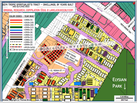
[Figure i.] (chart of yrs built)
The above chart, compiled by author L.A. Relics with data from the L.A. County Assessor, is a lot-by-lot assessment of the Tract and the area immediately adjacent, with each lot coded according to the period of construction. The result is a visual abstraction of a community that sprung up primarily between the 1910s and 1930s, with a handful remaining from the turn of the century. Those 45 or so houses from the teens to account for about 2/3 of the total number of homes around the Tract ( "total number" is defined as ± 80 ). The total number of lots on the tract containing dwellings is 50% less than the number of lots with no dwellings or any other kinds of structures.
Of course, findings from this data assume that the extant structures are the original ones upon that lot. Indeed, according to a local, one house, upon the Tract's bottommost plot joining Allesandro Street and featuring a koi pond, burned down in ±1979; this house was one of the originals.
MR. LANDACRE's EDENDALE
Extending from Allesandro Street northwest and up the hill into the Tract is a very peculiar street called El Moran Street. On this tiny, easily-overlooked street is a little 758 square foot wooden cabin dating from 1921, occupied by the woodcut artist Paul Landacre & Wife from the mid-30s until their deaths in 1963. Although the Spiritualist-related activity was past its zenith during his residence, Landacre carried on the agrarian spirit of the Tract. In his writings he documents his typical routine on El Moran Street:
" […] pruning trees…repairing the roof…feeding wildlife…
Of course, many artists live in wooded hillside areas, and so do other people.
And it must be conceded that to some of us,
this environment is not only valuable,
but absolutely necessary…
...to remind us that we are a part of nature."
(Paul Landacre 1958) [4]
In the late 1950s, Landacre witnessed the construction of the Allesandro portion of the 2 Freeway, which decimated wildlife and cut the hilly enclave of in two ((the 2 Freeway is today the de-facto divisor between Echo Park and the east side of Silver Lake)). It was an early sign that urbanization had extended to his agrarian backyard. Then, in April-May 1963, his wife and muse Margaret died suddenly of cancer, and the next month Landacre attempted suicide, lingering for a few days before dying of his wounds on June 3 [5]. Poignant, that the death of this fine artist and nature boy coincided with the demise of the ambiance he so relished.
Recently, in 2006, the City named the Landacre Cabin at 2006 El Moran a Historic-Cultural Landmark.
EL MORAN.
[ It would interesting be to trace the origin of this street name: Evidently, Moran is both a common Irish surname [6a], as well as the Syriac name for Jesus Christ [6b]…is it possible that the Spiritualists called this "Moran" person their God? :) ]
[ It would interesting be to trace the origin of this street name: Evidently, Moran is both a common Irish surname [6a], as well as the Syriac name for Jesus Christ [6b]…is it possible that the Spiritualists called this "Moran" person their God? :) ]
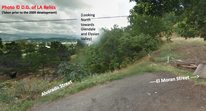
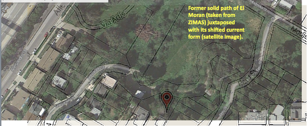
El Moran Street, southwest of Allesandro Street near Riverside Drive appears on maps from the
early 20th century. Earlier maps, from the late 19th century, imply some kind of path in its later place. As of
the 70s, it is erroneously called "Elmoran Street" on maps, records, navigation systems, and street signs [6c]. Aside from its historic significance, this street bears a quality of importance to urban geographers and local developers alike: the way in which its shape has morphed over time, owing to the land's qualities. The hilly neighborhoods of Echo Park/Elysian Heights have a layer of fine soil between them and the bedrock that forms the hills. This loose, fungal soil is the reason landslides are so frequent in the area, especially during the rainy seasons. Finer movement of the land is evident from the cracked concrete and sidewalks.
Overtime, a scant section of sidewalk that existed between Peru and El Moran Streets has sunk into the ravine leading to the Tract below. Finally, in the 1990s, the street was deemed a liability issue by the City, and was barricaded from vehicular travel, although pedestrian travel is still permitted. The pavement along El Moran is of very coarse pebble and cobblestone an older-fashioned treatment. The street is barely visible from numerous landslides and land shifts overtime.
AN URBAN ECOSYSTEM
Even in the absence of Landacre and the Spiritualists, wildlife on the Tract continued to thrive. The earliest clear photographs of the Tract date from the 1950s onward, with a small few from earlier. They depict a hillside of signature riparian trees and dry brush. By the time I had come around, the Spiritualist's Tract had practically become a naturally-formed arboretum. It boasted many of Coastal California's native trees (Juglans walnut species, Populus cottonwoods, and Quercus oaks) as well as native shrubs (Salvia sage species, Lupinus Lupines, Eriogonium buckwheats). The trees formed terrific canopies, like tunnels. Several non-native species also disseminated, including shade grasses, castor plants (Ricinus communis, one of the most poisonous plants in the world, by-the-way), and the infamous Jimsonweed (Datura Stramonium) which I was always advised against messing with a youth in Health class. Various native and non-native faunae also thrived in the area: owls, coyotes, swallows, sparrows. Several of the bird species relied on the protection of dense, dry brush, and trees for their nests. It was quite a remarkable mini-ecosystem.
ORDINANCES, ZONING, and NIMBY
Fast-forward to my own lifetime, as my interest in urban planning was growing: In 2007, a developer and landowner from Arcadia in conjunction with Van Daele Homes of Anaheim announced plans to dig up much of the hillside and build several homes on the lot by way of L.A.'s small-lot subdivision. The landowners made several generous compromises: they replanted trees, constructed a walking path, allocated open space, and lowered the size of a retaining wall (the last of which which actually may have been a bad idea, examined later). For a few years, though, a few things impeded their plans: the city's Protected Native Tree Ordinance, zoning limitations, and of course, local opposition (few communities organize and rally like the recent ones in Northeast LA).
i.) The City of Los Angeles' Protected Native Tree Ordinance. [7]
This ordinance specifies conditions under which "Laurels[…] Walnuts[…] Oaks[…] Sycamores […] [etc.]" shall be removed or kept.
Controversially, a lot of the trees removed did not satisfy a number of Ordinance criteria:
i.) they did not "interfere with proposed utility services or roadways";
ii.) as endemic, iconic, coastal trees, they did not "lack apparent aesthetic value";
iii.) as riparian trees, they had long root systems that shoot deep down and wide into the ground, in an effort to
get what water there may near the bottom of the ravines they usually rest upon. The sturdiness of these the
limbs, root systems, and weather tolerance is well-documented. Thus, many were definitely not "in danger of
falling due to an existing and irreversible condition".
The developer did abide by several other protocols as mandated by the ordinance:
i.) The razed trees were "replaced within the property by at least two (2) trees of the protected variety"
ii.) Several Walnuts were affected by the Thousand Kankers Disease [8], caused by the presence of the walnut twig beetle Pityophthorus juglandis in conjunction with a canker-producing fungus, Geosmithia morbida.
Thus, some trees fit the criteria to be considered "in substantial decline from a condition of normal health
and vigor […] . "
ii.) Zoning regulations.
In the early 70s, the 3-acre-total land was subdivided into 3 lots. In the 80s, it was briefly considered for a 30-lot subdivision. (Sheesh, that would have been awful.) Fast-forward to 2007: the then-owners requested a "Small Lot Subdivision", a hallmark of development in Los Angeles. L.A's Small Lot Subdivison Ordinance, for reference, was passed in 2005, to make use of "underutilized" lots in the city. In this case, the request was dividing the 3 lots into 16 lots to hold 9 homes, and a zoning change from R2-1VL and R1-1VL. This would allow a 15,000 sq.ft building to be built upon a lot with a minimum size of 5,000 sq.ft with 5 foot spacing between buildings. (Due to loopholes, buildings are often a mere inch apart in Small-Lot developments; not the case here).
iii.) Neighborhood opposition.
If you look at the area north of Downtown from a satellite map, one may notice that it is one of "the green parts" of L.A. These communities are very sensitive about their locale, development, and land razing. The Spiritualist Tract development and many other developments before it have historically prompted opposition in many of its several communities. It is a reminder of the reality of some communities: people are often mutually attracted to an area because of its locale or history, and feel strongly about maintaining it in their vision. They also react to events and organize on the assumption that their neighbors feel the same as they do.
In the end, the legal technicalities and appeals lasting until 2009 were to no avail. The Semi-Tropic Spiritualist Tract--the self-sustained arboretum, the urban ecosystem, the potential public park--was razed in mid-late 2011, rather brutally and excessively; dirty saws were used, trees were haphazardly cut, and far too many were removed than were necessary. The developers failed to repair the aging and cracking El Moran Street, or at least reinforce the land surrounding it.
I. LAND INTEGRITY: LANDSLIDE
Besides the subjective arguments against the "destruction of the locale", a problem with the removal of these particular trees is the effect upon the integrity of the land. As stated above, in section "EL MORAN.", the land in the area and adjacent to to it is hallmarked by very loose soil consistency. The trees that grow in these environments, riparian trees, work in synergy with the loose soil, and thrive for a reason: Riparian trees, often nestled above ravines, shoot their long root systems deep and wide into the soil to get as much water as they can, including water that may be toward the bottom of the ravine. These roots act as sort-of reinforcement bars, forming complex webs about the land the trees occupy and acting as preventative barriers against landslide and liquefaction (also explained in section "EL MORAN.", above). Within these lands, these "root" web systems act as a structural skeleton and are the reason why landslides in this area during the rainy seasons aren't, well, worse!!!
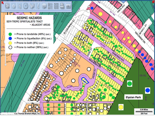
The land about the Spiritualist Tract required a pretty gnarly amount of grading to construct the Via Artis development. The land the development rests upon appears reasonably stable, and is in fact recorded by the assessor as such, but I find it fishy that the almost all of the land surrounding it is listed by the Assessor as being prone landslide. The communal space behind the development, that the developer generously allocated and maintained, is situated directly downhill from Peru Street. This space is rounded off by a diagonally upward-graded slope, leading to Peru and Modjeska Streets. Most of Peru and all of Modjeska are prone to landslide. In a major rain or seismic event, this could be destructive to the development below, especially in the absence of a higher retaining wall (which was lowered because of community demands).
"ZOMG WE WON'T BE ABLE TO BREATHE!!!"
One criticism of the development by the rallying community was the anticipated effect on the local atmosphere's oxygen quality. However, terrestrial plants (e.g. trees) account for less than 4% of our oxygen. This common misconception stems from the notion that because trees have more cells (and therefore more chloroplasts), they make more oxygen. But one also must remember that all those plant cells within trees each also have mitochondria, which use most of the of the oxygen produced by trees to metabolize food in order to grow tall.
What trees do achieve in an urban environment that is positive, and much more important, is a filter effect. Trees absorb the smoggy carbon emissions from passing vehicles and other sources. Air and its accompanying particles (like the carbon monoxides/dioxides from vehicular smog) go into the tree through stomata's of leaves. Both carbon dioxide and carbon monoxide diffuse into individual cells of the leaves and elsewhere on the body of the tree. Water and carbon DIoxide go through the process of photosynthesis (either the Krebs or Calvin cycles) to produce sugar. But because carbon MONoxide is not utilized for any of these purposes, it just kind of winds up attaching to molecules in some other part of the tree (particularly free radicals), oxidizing the tree. For reference, oxidation is when oxygen binds with another molecule to form some kind of Oxide; monoxides are not stable. Thus, trees are beneficial as large filters and carbon reservoirs. Pass through Elysian Heights/Echo Park on the 2 freeway and you'll see the signature eucalyptus trees. The leaves are blackened as a result of their absorption of smog emissions. Sadly, they eventually get all sorts of weird diseases and mutations.
Was the ecosystem that developed on the Tract a truly "natural" one? Of course, just because something grows well in an area doesn't mean its endemic to that area. So, have these florae always grown naturally in the hills of Northeast LA and elsewhere in the city and region? As it so happens, yes.--much of the the trees and shrubbery found on the hillside are naturally occurring in Southern California. As for this hillside, the earliest photographs dating from the early 20th century show a vast forest of these tall trees and shrubs, and photos from the late 50s and early 60s depict the hillside in largely the same state--not so much grassy, but nonetheless shrubby and woody. The oak and walnut species are present, but for the record: these are more so endemic to the Santa Monica Mountains and Hollywoods Hills, where the elevation allows them to get at the ocean breeze, and Live Oaks are also more so found in coastal NorCal areas (as with Populus fremontii).
The hillside indeed hosted many non-native and invasive florae (Ricinis Communis castor plants, Senecio mandraliscae blue chalk). As for the non-natives, they seemed to proliferate and sustain themselves well in their foreign environments. This is because region-specific plants can naturalize, or spread and adjust widely beyond their endemic region, most often thriving unabated in places with optimal soil pH and consistency, as well as ideal light cycles and strength. For example, Eucalyptus are not a native species--to the California Coasts, to California as a whole, or even the US; they're native to the arid, dry regions of Australia. But because the Los Angeles Basin and its hills are semi arid-zones with temperate seasons, Eucalypus can thrive just as well here. Fun fact: The cineole oil-based terpenoids of Eucalyptus trees are so flammable that trees caught up in wildfires have been known to--literally--explode. And we put that oil on our skin :D
In short, several qualities of the Tract--the climate, soil macro- and micronutrients, soil quality, and elevation--supported a number of native and non-native lifeforms. Thus, the kind of-arboretum that formed upon the Tract was indeed naturally self-sustainable.
SOUND WALLS, A/K/A GRAFFITI MAGNETS
If the razing of the Spiritualist's Tract wasn't enough, CalTrans has announced plans by the end of 2014 or 2015 to cut down the healthy Brazillian pepper trees (Schinus terebinthifolius) lining the Allesandro portion of the California State Route 2 that were planted in the late 50s/early 60s as part of its landscaping during construction. The idea is to build a sound-shielding wall. Surely, people know that sound travels conically in all directions, and not just straight outward in one direction. The area that the sound wall is ostensibly supposed to benefit is a hillside neighborhood. The VAST majority of Upper Echo Park/Elysian Heights will not benefit from even the most gigantic sound wall, as they are elevated, and not in the flats like the Via Artis development on the Spiritualist Tract, who would, in fact, benefit from the wall. What's more: even though Brazilian Pepper trees are not native species and are not mandated to be replanted by the Native Tree ordinance, they still could be subject to compulsory replanting because of the environmental impact; CalTrans is trying to get around this by attempting to have experts reclassify the Peppers as "shrubs".
Is this a scheme by the developers to benefit their development, and only their development? While our most primal fears would lead us to deduce this, we should not be so cynical. Surveys indicate that those on the Silver Lake side of the hill were the parties in opposition to the wall; the Echo Park/Elysian Heights side almost unanimously supported it.
HOUSING STOCK
The development makes good use of land, building up instead of out. LA's post World War II era saw a "building out" plan, wherein most of the development occurred away from the Downtown area. Most of these sprawling communities, consisted of single-family structures. This Cold War-era psychology of living isolated, as an individual on a plot of land only for them, runs contrary to the "new-urbanist" vision of living communally in buildings that are constructed in upward nodes, so as to make better use of the land and create a walkable city not so spread out.
Many of the more progressive developments around LA have implemented ZipCars on the properties, to be shared by residents, as a means to promote less cars on the road.
The Artis development also addresses a common grievance in the "New-Urbanist" city: the price of housing stock. Prices have traditionally--and are ostensibly always supposed to--lower with the construction of more housing, which in turn a practice that increases supply and thus lowering demand. And, to please the historic preservationists like myself, it probably results in fewer demolitions of historic homes…… so……
**pllllllttthhhhppppddd**.
However, prices for homes at the Artis development started at $669K [8], which is double that of a small Craftsman house in gentrifying Highland Park or Lincoln Heights. Not exactly promoting progress in housing accessibility.
REFERENCES:
[0a] Figures (i.) and (ii.) compiled using publicly-accessible data from City of Los Angeles Planning Website (ZIMAS.lacity.org) and from the County Assessor.
[1] Plesset, Ross. 2007. “Hidden Oasis Threatened By Development”. indymedia.org, Nov. 13. Retrieved July 29, 2013. (http://la.indymedia.org/news/2007/11/209930.php).
[2] Judge N.P. Connery, Lorigan, J., and Henshaw, J. 1912. SEMI-TROPIC S. ASSN. v. JOHNSON. California Supreme Court, Department Two. Case 126 P. 488 (Cal. 1912) - L.A. No 2913. San Francisco, CA.: Government Printing Office.
[3] Anonymous resident of Sunflower Avenue, personal interview, December 21, 2012, on-site in Elysian Heights, Los Angeles, CA. Los Angeles, CA
[4] Echo Park Historical Society, Author unknown. 2014. “EPHS - Paul Landacre”. Historic Echo Park, 2014. Retrieved August 10, 2013. (http://http://historicechopark.org/id101.html).
[5] Echo Park Historical Society, Author unknown. 2014. “EPHS - Paul Landacre”. Historic Echo Park, 2014. Retrieved August 10, 2013. (http://http://historicechopark.org/id101.html).
[6a] IrishCentral Staff Writer. 2014. "Tracing your Irish Ancestry - The Moran Clan". IrishCentral, June 21. Retrieved December 22nd 2013. (http://www.irishcentral.com/roots/genealogy/the-moran-clan-237351581.html)
[6b] Confirmed by members and priests of Syrian Orthodoxy.
[6c] Various.
[7] Los Angeles City Council, other legislators. 2006. City of Los Angeles Protected Native Tree Ordinance, Ordinance No. 177404. National Center for Education Statistics, NCES. Articles 2 and 7 of Chapter I; Article 6 of Chapter IV; Section 96.303.5. Los Angeles, CA.: Government Printing Office.
[8] Seybold, Steven, Dennis Hagen, and Andrew Graves. 2013. Pest Alert - Thousand Cankers Disease. United States Department of Agriculture. NA-PR-02-10. Washington, D.C.: Government Printing Office.
